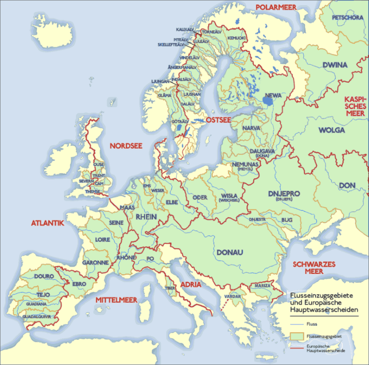
The map above shows the major rivers of Europe (blue lines), their drainage basins (green areas) and watersheds (red lines).
The map was created for German Wikipedia, which explains why all the river names are in German, although you can probably guess that Donau is the Danube, Themse is the Thames and the Rhein is the Rhine.
If you’d like to see a similar, yet more colourful version of the map have a look at previously published Rivers Basins of Europe Map.
If you found this map interesting, please share with a friend:

Ty Griffin says
Congratulations and thanks for a fascinating and informative map.
However: If you’re going to make a map of RIVERS, then perhaps you should have the RIVERS be the most prominent color/feature of the map, instead of country boundaries. If somebody looks at a map about RIVERS, they are presumably interested in RIVERS. They may or may not be interested in countries.
And if you were to use, for example, bold red lines to indicate country boundaries, and light blue lines to show RIVERS, then all of your hard work and good information about RIVERS would become secondary to the information about countries. In which case you should probably change the name of the map to “Countries of Europe, also showing rivers.”
Ty Griffin says
Ooops.
Please ignore my last comment. I guessed at the “country” lines without (a) studying them, and (b) reading the notes. Sorry.
Michael Maunsell FRGS says
A misleading title and map. The longest river in the British Isles is missing!
The River Shaannon in Ireland is longer than any river in Britain. Perhaps it is missing because the map appears to indicate that Ireland is NOT part of Europe, which it is. Also Ireland appears to have no rivers, riverbasins or watersheds.
Endai says
Ireland doesn’t belong to the Eropean continent, and if you take Europe to be a synonim of European continent then Ireland does not belong to Europe. Geographically speaking, not politically.
Thurston Harris says
The Shannon’s omission is a scandal!
Endai says
What is the difference between the red lines and the brownish orange lines?
Scott says
The red boundaries are watersheds and the brown boundaries are drainage basins.